
Machines cannot understand their surroundings in exactly the same way humans do.
A camera can capture colours and textures, but an image alone may not reveal the precise distance between the camera and every object in the scene. For technologies such as autonomous vehicles, robots, mapping aircraft and surveying equipment, knowing distance is essential.
LiDAR provides this information by using light.
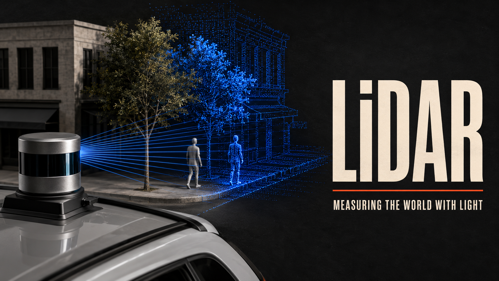
A LiDAR sensor sends laser pulses toward nearby surfaces and measures how long the reflected light takes to return. By repeating this process many times, the system can calculate the distance to a large number of points.
These measurements create a detailed three-dimensional representation known as a point cloud.
LiDAR technology is used to map forests, inspect infrastructure, guide robots, measure buildings, study archaeological sites and help vehicles understand the road around them.
What Is LiDAR?
LiDAR is a remote-sensing technology that uses laser light to measure the distance between a sensor and surrounding objects or surfaces.
The name is commonly understood as an abbreviation of Light Detection and Ranging.
A LiDAR system emits a laser pulse and waits for the reflected light to return. Because light travels at a known speed, the system can calculate distance using the time required for the round trip.
The basic calculation is:
Distance = (Speed of Light × Travel Time) ÷ 2
The result is divided by two because the light travels from the sensor to the object and then back to the sensor.
A single measurement provides one distance point. A LiDAR system can send large numbers of pulses in different directions, allowing it to build a three-dimensional map of the surrounding area.
How Does LiDAR Work?
A LiDAR system generally follows a repeated measurement process.
1. A Laser Pulse Is Emitted
The sensor sends a short pulse of laser light toward the environment.
The light may strike a road, building, tree, vehicle, person or another surface.
2. The Light Reflects
Part of the light reflects from the surface and travels back toward the sensor.
Different materials reflect light in different ways. A bright surface may produce a stronger return than a dark or highly absorbent material.
3. The Sensor Measures the Return Time
A detector records when the reflected light arrives.
The system compares the emission time with the return time. Even extremely small timing differences can represent measurable changes in distance.
4. Distance Is Calculated
The system uses the speed of light and the measured travel time to determine how far away the surface is.
5. The Direction Is Recorded
Distance alone is not enough to locate a point in three-dimensional space.
The LiDAR system also records the direction in which the pulse was sent. Combining direction and distance produces a three-dimensional coordinate.
6. A Point Cloud Is Created
The process is repeated across the sensor’s field of view.
The resulting collection of three-dimensional coordinates forms a point cloud representing the shape and location of objects in the environment.
What Is a LiDAR Point Cloud?
A point cloud is a collection of individual points positioned in three-dimensional space.
Each point normally has horizontal, vertical and depth coordinates. Additional information may include:
- Reflection intensity
- Time of collection
- Colour from a connected camera
- Classification
- Return number
- Sensor location
A point cloud may look like an object or landscape constructed from thousands or millions of dots.
Software can process these points to identify roads, buildings, trees, power lines, vehicles and other features.
Point clouds can also be converted into:
- Three-dimensional models
- Elevation maps
- Building measurements
- Surface models
- Contour maps
- Infrastructure plans
- Navigation maps
The density and accuracy of the point cloud depend on the sensor, distance, scanning method, environment and processing system.
Main Components of a LiDAR System
A complete LiDAR system includes more than a laser.
Laser Source
The laser produces the light pulses used for measurement.
Its wavelength, power, pulse duration and frequency depend on the intended application.
Scanner
The scanner directs laser pulses across the required field of view.
Some systems use moving mirrors or rotating assemblies. Others use designs with few or no major moving parts.
Photodetector
The detector receives the reflected light and converts it into an electrical signal.
It must recognise weak reflections and accurately record their arrival times.
Timing System
The timing system measures how long each pulse takes to return.
Because light travels extremely quickly, the measurement must be highly precise.
Positioning and Motion Sensors
Mobile and airborne LiDAR systems need to know the position and orientation of the sensor.
Satellite navigation and inertial measurement systems help determine where each point belongs in the larger map.
Processing Software
Software converts raw measurements into a useful point cloud.
It may remove noise, combine multiple scans, classify objects and create maps or models.
Different Types of LiDAR
LiDAR systems can be categorised according to where and how they operate.
Airborne LiDAR
Airborne LiDAR systems are mounted on aircraft, helicopters or drones.
They scan the ground from above and can map large areas efficiently.
Common applications include:
- Topographic mapping
- Flood analysis
- Forestry
- Power-line inspection
- Environmental research
- Urban planning
Terrestrial LiDAR
Terrestrial systems operate from fixed positions on the ground.
A surveyor may place a scanner on a tripod and capture the shape of a building, construction site or landscape.
Several scans can be combined to create one detailed model.
Mobile LiDAR
Mobile LiDAR is mounted on a moving platform such as a car, train, boat or backpack.
It can capture roads, tunnels, railway lines and urban environments while the platform is moving.
Automotive LiDAR
Automotive systems are designed to help vehicles measure the location of surrounding objects.
They may detect road edges, vehicles, cyclists, pedestrians and other obstacles.
LiDAR is usually combined with cameras, radar and other sensors rather than used alone.
Bathymetric LiDAR
Bathymetric LiDAR is designed to measure water depth and map underwater surfaces in suitable conditions.
It uses light capable of travelling through water and measures reflections from the surface and the bottom.
Water clarity, depth and environmental conditions affect its performance.
Flash LiDAR
Flash LiDAR illuminates a larger area at once and captures depth information across the scene.
Its operation is somewhat comparable to taking a depth photograph rather than scanning one narrow direction at a time.
LiDAR vs Radar
LiDAR and radar both measure distance using reflected energy, but they use different parts of the electromagnetic spectrum.
LiDAR uses laser light, while radar uses radio waves.
| Feature | LiDAR | Radar |
|---|---|---|
| Signal type | Laser light | Radio waves |
| Detail | Can produce highly detailed spatial data | Often provides lower spatial detail |
| Distance measurement | Precise under suitable conditions | Effective across long distances |
| Weather performance | Can be affected by fog, rain, dust and snow | Often performs better in poor weather |
| Object speed | Can be calculated across scans | Particularly effective at direct speed measurement |
| Common uses | Mapping, robotics and detailed 3D sensing | Aviation, weather, vehicles and long-range detection |
Neither technology is universally better.
LiDAR provides detailed shape and depth information. Radar can operate effectively across longer distances and in difficult weather.
Combining the two can provide a more reliable understanding of the environment.
LiDAR vs Cameras
Cameras record visible appearance, including colour, texture and written information.
LiDAR records distance and three-dimensional structure.
A camera may identify the colour of a traffic light, while LiDAR can measure the shape and position of the pole supporting it.
Cameras can struggle when lighting conditions change. LiDAR supplies its own light and can often measure depth in darkness. Strong sunlight and reflective conditions may still affect some systems.
LiDAR generally produces less visual detail than a camera.
For this reason, many systems combine both:
- Cameras classify objects.
- LiDAR measures shape and distance.
- Radar detects range and relative speed.
- Software combines the information.
This process is called sensor fusion.
Real-World Applications of LiDAR
LiDAR is useful wherever accurate three-dimensional measurements are required.
Autonomous and Assisted Driving
Vehicles can use LiDAR to detect road boundaries, nearby vehicles, pedestrians and other obstacles.
The point cloud provides a three-dimensional view of the surrounding environment.
A safe driving system still requires robust software, multiple sensors, careful testing and the ability to handle unexpected conditions.
Surveying and Construction
Surveyors use LiDAR to measure land, buildings and construction sites.
A detailed scan can document existing conditions, calculate dimensions and compare construction progress with design plans.
Forestry
Airborne LiDAR can measure forest height and structure.
Some laser pulses pass through gaps in leaves and return from branches or the ground. Researchers can use the resulting data to estimate tree height, canopy density and terrain beneath vegetation.
Archaeology
LiDAR can reveal landscape features that may be difficult to see from the ground or through dense vegetation.
Researchers can identify possible foundations, roads, earthworks and changes in terrain. The findings still require interpretation and, in many cases, physical investigation.
Agriculture
Farmers and researchers can use LiDAR to measure crop height, plant structure and terrain.
This information can support drainage planning, crop monitoring and field analysis.
Architecture
A building can be scanned to create an accurate record of its shape and dimensions.
Architects may use the point cloud when renovating older structures for which complete drawings are unavailable.
Infrastructure Inspection
LiDAR can examine roads, bridges, tunnels, railways and power lines.
Repeated scans can help teams identify changes in position, vegetation growth or structural condition.
Robotics
Robots use LiDAR for localisation, navigation and obstacle detection.
A warehouse robot, for example, can compare current measurements with a stored map to determine its position.
Mining
Mining companies use LiDAR to map pits, tunnels, stockpiles and changing terrain.
Remote measurement can reduce the need for workers to enter some hazardous areas.
Coastal and Flood Mapping
Elevation models created using LiDAR can support flood-risk analysis, drainage planning and coastal monitoring.
The quality of the analysis depends on the accuracy and age of the data, as well as the assumptions used in the model.
Smartphones and Consumer Devices
Some mobile devices use depth-sensing technology for photography, room measurement and augmented-reality experiences.
The size, range and performance of these sensors differ from professional surveying or automotive systems.
Benefits of LiDAR Technology
LiDAR provides several important advantages.
Accurate Distance Measurement
LiDAR can measure the position of surfaces with high precision under suitable operating conditions.
Detailed Three-Dimensional Data
The point cloud represents depth directly instead of attempting to estimate it only from a flat image.
Operation in Low Light
Because LiDAR emits its own light, it can function in darkness.
Rapid Data Collection
Airborne and mobile systems can capture large areas more quickly than traditional point-by-point measurements.
Measurement of Complex Shapes
LiDAR can record buildings, machinery, trees and irregular terrain with substantial detail.
Repeatable Monitoring
Scanning the same location at different times can reveal movement, growth, erosion or construction progress.
Limitations of LiDAR
LiDAR also has practical limitations.
Weather Sensitivity
Fog, rain, snow and dust can scatter or block laser light.
This may reduce range, introduce noise or produce unreliable measurements.
Cost
High-performance sensors and processing systems can be expensive.
Costs also include positioning equipment, software, storage and trained personnel.
Large Data Volumes
Detailed point clouds can contain enormous numbers of measurements.
Storing, transferring and processing this information requires suitable computing resources.
Surface Properties
Dark, transparent, reflective or highly absorbent surfaces can affect the quality of returned signals.
Glass, water and polished metal may produce complicated measurements.
Limited Object Understanding
LiDAR records shape and distance but may not identify what an object is.
Artificial intelligence and camera data are often required for classification.
Moving Objects
If the sensor or subject moves during scanning, the point cloud may contain distortion.
Positioning and motion compensation are particularly important for vehicles and aircraft.
Range and Resolution Trade-Offs
Systems designed for long-range detection may differ from systems intended for highly detailed nearby scanning.
No single sensor is best for every situation.
Is LiDAR Safe?
LiDAR systems use laser light, so safety depends on factors such as wavelength, power, beam design and exposure.
Commercial systems intended for use around people are generally designed to meet relevant laser-safety requirements.
Users should not assume that every laser-based device is harmless. Industrial and experimental systems must be installed, operated and maintained according to their safety classification and manufacturer instructions.
How Artificial Intelligence Uses LiDAR Data
Artificial intelligence can analyse point clouds and identify patterns within them.
A model may be trained to recognise:
- Vehicles
- Pedestrians
- Road surfaces
- Trees
- Buildings
- Power lines
- Warehouse shelves
- Structural defects
Point-cloud processing can be technically challenging because the points are irregularly distributed rather than arranged in a simple image grid.
Developers may convert the data into other formats or use models designed specifically for three-dimensional information.
AI does not replace measurement quality. Poor calibration, weak sensor returns or incomplete data can still produce unreliable results.
Frequently Asked Questions About LiDAR
What is LiDAR in simple terms?
LiDAR is a technology that sends laser pulses toward objects and measures how long the reflected light takes to return. It uses this information to calculate distance and create a 3D map.
What does LiDAR stand for?
LiDAR is commonly expanded as Light Detection and Ranging.
Does LiDAR work in darkness?
Yes. LiDAR emits its own light, so it does not depend on normal visible illumination in the same way a standard camera does.
Can LiDAR see through walls?
No. Standard LiDAR cannot see through solid walls. It measures light reflected from the surfaces it can reach.
Can LiDAR see through trees?
Some airborne laser pulses may travel through gaps between leaves and branches, allowing the system to measure parts of the ground beneath vegetation. It does not pass directly through solid plant material.
Is LiDAR better than radar?
LiDAR usually provides more detailed three-dimensional shape information. Radar often performs better over long distances and in difficult weather. Many systems use both.
Why do autonomous vehicles use LiDAR?
LiDAR can give vehicles detailed distance and shape information about roads, vehicles, pedestrians and nearby obstacles.
What is a point cloud?
A point cloud is a collection of three-dimensional points representing the surfaces detected by a sensor.
Final Thoughts
LiDAR allows machines to measure the world using light.
By sending laser pulses and timing their reflections, a LiDAR system can calculate distance and create a detailed three-dimensional point cloud.
This capability makes it valuable for mapping, construction, forestry, archaeology, robotics, infrastructure inspection and vehicle perception.
LiDAR is not a complete replacement for cameras or radar. Cameras provide colour and visual context, while radar performs strongly across long distances and difficult weather. LiDAR contributes precise depth and shape.
The strongest systems often combine all three.
As sensors become more compact and processing tools improve, LiDAR will continue helping machines move beyond simply seeing the world to measuring and understanding its three-dimensional structure.